
Mastering the Waves: Captain Scott's Approach to Marine Weather Planning
- Scott Rainey

- Jul 22, 2025
- 4 min read
Updated: Mar 17
As a USCG 100 Ton Master with over three decades of navigating diverse waterways, I've learned that truly understanding and planning for marine weather is the bedrock of a safe and successful voyage. Whether you're embarking on a short coastal hop or a multi-day delivery, neglecting a comprehensive weather strategy can turn an enjoyable trip into a challenging one. At Coastal Yacht Delivery, we prioritize meticulous planning for every vessel, from 21-footers to 70+ foot motor yachts. Here's an in-depth look at my personal approach and the powerful tools I rely on.
The Foundation: Early & Continuous Monitoring
My weather planning begins long before I even step aboard a vessel. I start monitoring patterns more than a week out from any planned passage. This isn't just about getting a general idea; it's about discerning broad trends, identifying potential weather systems forming, and understanding the general "personality" of the forecast for the upcoming period. This early bird approach provides valuable lead time to make strategic decisions, such as adjusting departure dates or considering alternative routes if challenging conditions appear likely.
Deep Dive with Data: My Go-To Tools
While there's a wealth of weather information available, I rely on a select few tools that provide the precision and detail necessary for professional deliveries:
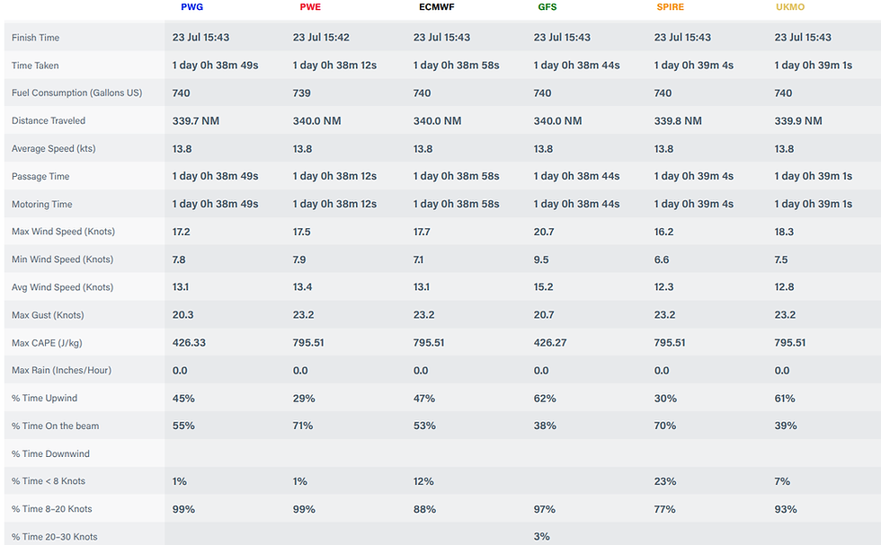
PredictWind: The Power of Model Comparison PredictWind is a cornerstone of my planning. Its greatest strength, in my opinion, lies in its ability to display and compare various global weather model predictions side-by-side using intuitive line graphs. Instead of just looking at one forecast, I can see how different reputable models (like GFS, ECMWF, or others) are projecting conditions over time.
Why this matters: If multiple models align closely on wind speeds, directions, and wave heights, it significantly increases my confidence in that forecast. Conversely, if there's a wide divergence between models, it's a red flag. It tells me the forecast is less certain, and I need to exercise greater caution, build in more flexibility, or consider delaying. This comparative analysis is crucial for risk assessment.
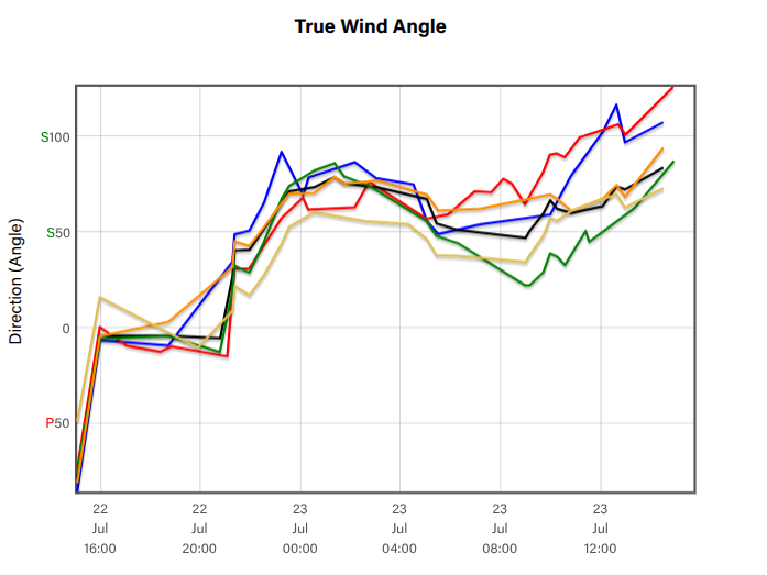
Line graph illustrating the divergence of weather models in predicting the true wind angle over time, displaying variations in direction starting from July 22nd until midday July 23rd.
NOAA Data: The Official Word The National Oceanic and Atmospheric Administration (NOAA) provides the official marine forecasts for US waters. I always cross-reference PredictWind's insights with NOAA's detailed marine weather statements, coastal forecasts, and offshore warnings. This ensures I'm aligning my planning with the authoritative information, particularly concerning any watches or warnings issued by the national weather service.

Windy: Visualizing the Dynamics For a highly visual and intuitive understanding of conditions, Windy is an excellent complement. Its animated maps bring wind patterns, gusts, wave heights, and even swell directions to life. This visual representation helps me quickly grasp the overall flow of weather systems and how conditions might evolve along a planned route. It's particularly useful for identifying localized effects or significant changes in sea state.
The Crucial Beyond: Looking Past Your Arrival
Here’s a critical piece of advice that often gets overlooked: Don't just look at the weather during your anticipated passage. Always extend your forecast review to include the days following your planned arrival.
Why is this so important? Because even the best-laid plans can encounter unforeseen challenges. An unexpected engine issue, a fouled propeller, a sudden squall that forces you to slow down, or even needing to anchor overnight due to fatigue – any of these can extend your time at sea. If an issue arises, you need to know what kind of weather you might be facing as you troubleshoot, seek refuge, or await assistance. Knowing if a strong front is approaching in 24-48 hours after your planned arrival can dictate whether you push harder to make port or find a safe anchorage to ride it out. This foresight is invaluable for preparing for contingencies and ensuring continuous safety.
Integrating High-Speed Satellite Data
As we move into the 2026 season, the ability to pull high-resolution GRIB files via Starlink and other high-speed satellite arrays has changed the "set it and forget it" mentality of offshore weather. I now advocate for active route polling—updating your PredictWind models every 6–12 hours while underway. This allows us to pivot in real-time if a model starts to trend toward a divergence we didn't see at the dock. Whether I'm on a 44-foot Tiara or a larger motor yacht, having that live data stream ensures that our "contingency window" is always backed by the most recent atmospheric data available.
The Final Pre-Departure Check
No matter how much prior planning is done, the most crucial weather assessment happens the night before or, ideally, the morning of departure. Marine conditions can change rapidly, and this final check ensures I have the most current information before leaving the dock. It's about staying flexible and being prepared to adjust plans on the fly if conditions warrant.


Comments